
Żuławy Wiślane: geography, history and attractions of the unique land of the Vistula Delta
- Damian Brzeski
- Jun 7, 2025
- 15 min read
Did you know that the lowest point in Poland is over two meters below sea level? And yet this place is full of life, history, and... milk.
Żuławy Wiślane is a land that man literally tore from the water - and over time transformed into one of the most fascinating places on the map of Poland.
What do Dutch refugees, Gothic churches and windmills have in common with the Polish Vistula Delta? Immerse yourself in the story of a land that never ceases to surprise.
Żuławy Wiślane: a land wrested from the water
Żuławy Wiślane is a true pearl on the map of Poland – a mesoregion with a unique character that delights not only geographers, but also those who simply like to discover places with soul.
Situated at the mouth of the Vistula River, in the coastal zone of the Baltic Sea, Żuławy Wiślane lies in the north-central part of the country, on the border of the Pomeranian and Warmian-Masurian Voivodeships.
This is where the longest Polish river ends, flowing lazily through one of the most extraordinary deltas in Europe.
How did Żuławy come into being? A story about Żuławy and alluvial soils
The Żuławy Wiślane mesoregion is also the youngest geographical region of our country - its history dates back to about six thousand years. Żuławy Wiślane was formed from river sediments, the so-called "żuły", carried over thousands of years by the Vistula and its branches.
These sediments gave rise to alluvial soils, some of the most fertile soils in Poland. The word "żuł" is most likely the source of the name Żuławy .
For thousands of years, the Vistula River has been building its delta here, changing its arms, creating new floodplains and gradually transforming shallow bays into land.
The Dutch Trace – Mennonites, Olęders and the Fight Against Water
But it wasn't just nature that had something to say here. The landscape of Żuławy is the fruit of centuries of human effort — literally. Building flood embankments, digging canals, systematically draining wetlands — these are not actions of recent decades, but a process that has lasted hundreds of years.
That is why the area of Żuławy Wiślane is often called "the land wrested from the water". And there is more truth in this than it may seem.
Who were the Mennonites? Refugees from the Netherlands, masters in taming water. It was thanks to them that Żuławy changed from marshy swamps into an agricultural paradise.
When you visit Żuławy Wiślane , it is hard not to get the impression that this is a place like no other. The landscape of Żuławy is based on polders, drainage ditches, houses with arcades and historic windmills.
All this means that they are often referred to as the "Polish Netherlands". This comparison is not accidental - since the 16th century, the region was settled by Mennonites , also known as Olęders , who came from the areas of today's Netherlands and Germany .
The settlement of Żuławy Wiślane is a separate story, full of knowledge, persistence and excellent water engineering. It is thanks to them that the irrigation of Żuławy Wiślane and its development became possible.
They created drainage systems, founded villages on artificially raised terps and built characteristic houses which are still a symbol of this land today.
Life Below Sea Level
The Vistula Żuławy are famous for the fact that, although they are located below sea level, they are extremely fertile and well-developed agriculturally.
It is this fight against water, and at the same time using its potential, that creates the problem of Żuławy Wiślane – a topic that is still relevant in the era of climate change.
It is not without reason that it is said to be one of the most difficult places to protect against floods in the whole of Poland - the system of pumps, locks and embankments must operate non-stop to keep the ground dry.
All this makes the landscape of Żuławy more than just a view – it is history, nature and human determination intertwined into one.
Although most of Żuławy lies only a few metres above sea level, in terms of value – geographical, cultural and historical – it reaches true heights.
Look deeper and you will see that Żuławy Wiślane is famous not only for its landscapes, but also for the people who have been able to cooperate with the river for centuries. Because it is not just land - it is history written in mud, water and wind.

Geography and the natural environment: a landscape shaped by water
Żuławy is a place where nature and man have been in dialogue for centuries - not always easy, but incredibly creative. It is here that the river, sea and human ingenuity have come together to create a landscape from another world: flat as a table, but full of history, challenges and hidden beauty.
The inverted triangle of the Vistula Delta – what does the layout of Żuławy look like?
If you look at a map of northern Poland, you can easily notice the characteristic shape of the Vistula Delta – it resembles an inverted triangle, the lines of which are drawn by rivers and the Vistula Spit.
It is in this geometric arrangement that lies the secret of one of the most demanding and at the same time fascinating landscapes in the country.
Żuławy Wiślane , with an area of approximately 1,700 km² , resembles an inverted triangle in shape - its apex is located at the Vistula fork into the Wisła-Leniwka and the Nogat , and its base is marked by the Vistula Spit .
Administratively, the area of Żuławy Wiślane lies within the borders of two voivodeships: Pomerania and Warmian-Masurian.
In terms of geographical division, Żuławy Wiślane is divided into three main units:
Żuławy Gdańskie (on the western side of the Vistula River, approx. 39 thousand ha),
Żuławy Wielkie , including Żuławy Malborskie (between the Vistula and the Nogat, over 83 thousand ha),
and Żuławy Elbląskie (on the eastern side of the Nogat, approx. 48 thousand ha).
Each part has its own separate hydrographic system – Żuławy Gdańskie lies in the Motława and Martwa Wisła river basins, Malborkskie in the Szkarpawa and Nogat river basins, while Żuławy Elbląskie belong to the Elbląg and Nogat river basins.
Depressions, cryptodepressions and the lowest points
What are Żuławy Wiślane famous for? First of all, about 28% of their area is below sea level - that's 465 km² of depressions.
For years, the lowest point in Poland was considered to be Raczki Elbląskie (1.8 m below sea level), but newer measurements indicate that this record has been taken over by Marzęcino - a natural depression reaching 2.2 m below sea level.
The largest depression area is located around Lake Drużno – a shallow, heavily overgrown delta lake, which is not only a cryptodepression, but also an area protected under the Natura 2000 programme and the Ramsar Convention.
Lake Druzno is home to rare bird species and an important link in the network of European wetlands.
Water as an element and a tool for development
The Żuławy Wiślane mesoregion is almost completely flat, and its absolute height in many places does not exceed 1–2 metres above sea level.
This flat landscape is the result of thousands of years of river sedimentation , which began in earnest about 5–6 thousand years ago when the level of the Baltic Sea stabilised.
Where is the greatest depression in Poland? In Marzęcino in Żuławy – 2.2 meters below sea level. This is the lowest point in the country, wrested from water and time.
Water in Żuławy is not only the past, but also the present. Shallow groundwater levels, frequent flooding and high salinity are everyday challenges.
Controlling them was possible thanks to the drainage system , which combines gravity and pump drainage. Today, as much as 70% of the entire Vistula Delta area is polder land — requiring constant drainage.
The Vistula Śmiała, the Vistula Przekop and the entire river network
The mouths of the Vistula have changed over the centuries, but the turning point was the year 1840 - then the Wisła Śmiała was created, and after the disastrous flood in 1888, the famous Przekop Wisły was built (completed in 1895).
Thanks to this, the risk of flooding was reduced and the geographical location of the Vistula Żuławy was stabilized.
Apart from the Vistula and the Nogat, the landscape also includes the Motława, Szkarpawa, Radunia, Święta, Tuga and Elbląg rivers, as well as canals and drainage ditches , which densely crisscross almost the entire region.
The agricultural heart of northern Poland
Depression areas that may seem inhospitable are in fact some of the most fertile areas in Poland . Over 90% of the land here is covered by alluvial soils — fertile, heavy soils that allow for record yields of grain, rapeseed, sugar beets and hay.
It is no coincidence that the cuisine of Żuławy Wiślane is based on what grew in this “land of water”. Agriculture is intensive, commercial and modern. What is Żuławy famous for? Among other things, it is milk, which comes from developed dairy cattle breeding.
Forests, meadows, birds – nature has a voice too
Although the landscape of Żuławy is mainly associated with fields and canals, there is no shortage of forests here either. The Mątawski Forest , with its ash and poplar trees called the "Twelve Apostles", is one of the last larger forest complexes.
The Vistula Spit is a natural barrier against the wind and a place of great natural importance.
In the north, at the mouth of the Vistula, there is Mewia Łacha — a reserve that is a haven for waterfowl and seals.
Willows along the ditches, tree alleys and cemetery plantings complete the landscape of Żuławy , which from a bird's eye view resembles a precise pattern of Dutch embroidery.
What are Headed Willows? Headed willow is a characteristic way of leading (cutting) trees of the Salix genus (i.e. willows), which is created as a result of regular, many-year pruning of shoots growing from one place - the so-called "head".
The landscape of Żuławy is a story of human success and engineering over nature
There is no other place like this in Poland. The landscape of Żuławy Wiślane is not only the effect of nature - it is the work of man, who has tamed water, but has never stopped cooperating with it.
This duality of the element that simultaneously gives life and threatens makes Żuławy a fascinating place. And that is why it is worth getting to know it – up close, on foot, by bike or… by kayak.
History and settlement: in the footsteps of the Olęders and the Teutonic Knights
Before Żuławy became the vibrant, agricultural heart of northern Poland, it was a wild, untamed landscape – marshy, uncertain, full of challenges.
And it was these challenges that attracted people who, over the centuries, not only settled here, but also turned this part of the Vistula Delta into one of the best-developed lands in Europe.
From amber hunters and embankment builders, through the Teutonic Knights, to the hard-working Mennonites and post-war settlers – the history of Żuławy is a tale of drainage, building and the constant struggle against the forces of nature and history.
The first traces of settlement and the Amber Road
The history of Żuławy Wiślane is a story of a constant struggle with the element of water and successive waves of settlement that left behind a rich heritage.
The oldest traces of human presence in Żuławy and the Spit are dated to around 2500 to 1700 BC, which is confirmed by archaeological findings.
It is assumed that these settlements were of a seasonal nature and were associated with fishing, seal hunting, and amber fishing and processing, which indicates the role of the Vistula Delta in the so-called Amber Trade Route.
In the early Middle Ages (8th–11th centuries), the settlement of Truso near Elbląg was discovered, an important trade and craft centre with extensive economic contacts.
Already in the mid-13th century, the first attempts were made to create the foundations of a flood protection system by building embankments along the Vistula and Nogat rivers.
The Teutonic Knights and the beginnings of land improvement
The period of Teutonic rule (until 1466) was crucial for the future of Żuławy. After conquering Gdańsk Pomerania, the Teutonic Knights moved the seat of the Grand Master to Malbork, right on the border of Żuławy.
Malbork became the capital of the Teutonic state for 150 years, and its castle, the largest Gothic castle in the world, is today included on the UNESCO list.
The Teutonic Knights pursued an active settlement policy, developing inaccessible areas, and the incoming North German and Dutch settlers played a large role in draining the wastelands.
In 1407, the document "Die gemeine Landtafel" was issued, organising land improvement activities and introducing a flood control self-government whose task was to ensure the proper condition of land improvement facilities.
About 30 brick Gothic churches have been preserved from this period, their lofty towers enlivening the landscape and testifying to the architectural skill of their builders.
The Golden Age and the Arrival of the Mennonites
After the second peace of Toruń in 1466, Żuławy became part of the Polish state for three hundred years. This period brought profound administrative and economic changes, and the free Vistula route contributed to the growth of trade.
In the 16th century, a new wave of settlement arrived in Żuławy, mainly Dutch and North German emigrants, known as Mennonites (Olędrzy).
Fleeing religious persecution in the Netherlands, they found refuge and economic freedom in tolerant Poland.
Thanks to their unique skills in draining swamps, digging ditches and drainage channels, building flood embankments and wooden windmills that pumped water from the fields, they transformed Żuławy into an extremely fertile area, creating "a piece of Holland in Poland".
Who were the Olęders? Settlers from Holland and northern Germany who brought to Żuławy the knowledge of how to fight water. They built embankments, dug canals and created villages on artificial hills – as if they had brought a piece of Holland to Poland.
The Mennonites were good farmers, engaged in farming, cheese-making, brewing and distilling, although they lived modestly and somewhat on the sidelines of the local community.
Their influence on the landscape of Żuławy is still visible today in the form of characteristic farmsteads on artificially raised hills called terps, unique arcade houses and original cemeteries with stone steles and richly carved tombstones.
Partitions, Germanization and the Vistula Canal
As a result of the first partition of Poland in 1772, Żuławy came under the rule of West Prussia.
The restrictive Prussian policy towards Mennonites who refused to serve in the military led to mass emigration of part of that community, mainly to Ukraine , although those who remained were Germanized.
The Prussian period was the next stage in the economic development of the region, and in 1895 the monumental Vistula River canal was made near Świbno, which significantly reduced the risk of flooding.
After World War I, in 1920, most of Żuławy found itself within the borders of the Free City of Gdańsk, experiencing a period of economic prosperity and modernization of the land improvement system.
World War II and the reconstruction of the region
Unfortunately, the outbreak of World War II interrupted the development of Żuławy. In 1939, the Stutthof concentration camp was established in Sztutowo on the Vistula Spit, where over 65,000 people died.
The culmination of the tragedy was the deliberate flooding of Żuławy by retreating German troops in March 1945 , by blowing up embankments, pumping stations and locks. The water flooded most of the region, destroying the entire achievements of many generations.
After liberation, an extremely difficult hydrotechnical and land improvement operation was launched, code-named "Żuławy" , which lasted until 1949, bringing the region back to life and enabling the repopulation and development of the depression areas by new settlers, mainly from the Eastern Borderlands.
History written in layers
The history of Żuławy is like a palimpsest, where each era – from the Teutonic Knights, through Polish rule, Mennonite settlement, the Prussian period, to the dramatic events of World War II and post-war resettlements – has left clear, yet interconnected traces in the landscape, architecture and social fabric.
This layered heritage gives the region an extraordinary, multi-dimensional depth. The repeated cycles of destruction, both by water and war, and then heroic reconstruction and adaptation, attest to the extraordinary resilience and innovation of the people of Żuławy.
It is not just a chronological record of events, but a story of human perseverance in the face of extreme challenges.

Architecture and culture: the showcases of Żuławy
The architecture and culture of Żuławy Wiślane are inextricably linked with the history of the region and its specific environmental conditions.
They were formed over the centuries, reflecting the influences of the Teutonic Knights, Mennonites (Olęders), Prussians and people arriving after the war.
It is a material and spiritual landscape that has not only survived centuries of struggle with water, but also tells the extraordinary story of those who lived and live here.
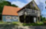
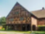
Arcaded houses – symbols of Żuławy architecture
The most recognizable landmarks of Żuławy are arcade houses . These unique structures with a wooden frame and decorative "Dutch" brick have a characteristic floor supported by wooden columns (from 4 to 9). The more columns, the greater the prestige of the owner.
What is an arcade house? It is a symbol of Żuławy – a village manor with a protruding floor supported by wooden columns. The more columns, the richer the owner. Here, the form spoke of status.
Initially, they served as granaries, and over time they gained a representative role. The interiors of such houses housed stairs with an elaborate balustrade, tiled stoves, decorative doors and tiles. The most beautiful examples can be found in Trutnowy, Marynowy, Nowa Kościelnica and Przemysław .
Hydrotechnical heritage – windmills, canals and locks
Windmills were and are an inseparable element of the landscape – often not only mills, but also drainage devices.
One of the most interesting examples of engineering genius is the Elbląg Canal , where ships overcome level differences by "driving on grass".
Equally impressive is the lock in Marzęcino from 1884, which protected the Panieński Canal and the village from the Vistula Lagoon.
Stone Stories – Mennonite Cemeteries
Many of the Mennonite cemeteries are now forgotten enclaves, but their layout, symbolism and gravestones say more than many a textbook.
Regular rectangles, steles with doves, anchors, hourglasses – all this speaks of the values and faith of the Olęders.
The largest of them is located in Stogi near Malbork , where over 350 tombstones have been preserved.
Gothic churches – spiritual and architectural heritage
Gothic, often brick churches with a single nave and a massive tower are today the decoration of almost every village. An example? The church in Kmiecin from 1344, whose form gives the impression of two connected buildings.
Żuławy cuisine – flavors from many sources
The cuisine of Żuławy Wiślane has been influenced by all the cultures that have passed through the region. There is fish in every form, bigos with fish, Żuławy meatballs , Werderkäse cheese, "machandla" - Mennonite juniper spirit, and even Szuwar beer with calamus.
You can try all this at Gospoda Mały Holender in Żelichów – in a restored arcade house.
Customs and holidays - from Christmas to fairs
Although the post-war population exchange changed the social fabric of Żuławy, traditions and customs survived.
On Christmas Eve, colored wafers are given to animals, and sailing traditions live on in festivals, fairs, and crafts.
Folklore is still vibrant – just visit one of the local festivals to see for yourself.
Tourism and the Present: Rediscovering Żuławy
Today's Żuławy Wiślane is focusing on the development of tourism - and they are doing it wisely. The region is increasingly bold in using its natural and cultural potential, and at the same time it does not forget about what is most precious: water. It is precisely with water that one of the region's greatest hits is associated - the Żuławy Loop .
This waterway, which is over 300 kilometres long, creates a veritable network of connections between the Vistula, Martwa Wisła, Szkarpawa, Nogat, Tuga, Wisła Królewiecka, Elbląg, Pasłęka, and the Vistula Lagoon.
It is part of the great International Waterway E70 , stretching all the way from Rotterdam. Sailors, kayakers, fans of motor boats and houseboats can find 355 mooring places , water points, toilets and places to party.
All this to fully immerse yourself in the charms of this land.
On two wheels through the delta – Żuławy cycling region
Those who prefer pedals to oars will find something for themselves here. The Vistula Cycle Route (part of the European EuroVelo 9 ) is a real treat for lovers of two wheels.
The section from Gdańsk to Tczew is particularly recommended – it is picturesque, running along flood embankments with a view of Żuławy Gdańskie.
In addition, we have the Elbląg Canal Trail , EuroVelo 10 , and the Mennonite Trail , which connects places of memory and architecture related to former settlements. Each kilometer is not only physical activity, but also an encounter with history and nature .
Cities, reserves, souvenirs – what is worth seeing?
The tourist map of Żuławy cannot be complete without hits:
Malbork Castle – a Gothic fortress listed on the UNESCO World Heritage List,
Elbląg – with the rebuilt Old Town and the Piekarczyk monument,
Stutthof Museum in Sztutowo – a place of remembrance for the victims of World War II,
Mewia Łacha Reserve – a mecca for birdwatchers and seal fans,
Żuławy Historical Park in Nowy Dwór Gdański – the heart of knowledge about the region,
Bażantarnia Park in Elbląg – greenery and silence at your fingertips.
Tourism and ecology – the future of Żuławy will be marked by balance
Żuławy, although beautiful, is not free from challenges. Climate change , the growing threat of flooding , soil erosion - all this requires not only vigilance, but also action.
Therefore, the Development Strategy for the Żuławy Functional Area until 2050 is being created, the aim of which is to reconcile tourism, agriculture and environmental protection.
Local associations – such as the Nowodworski Club or the Żuławy Association – do a great job in education and promotion of heritage. After all, it is not only about attracting tourists , but also preserving what makes Żuławy unique – for generations.
Żuławy – Dutch atmosphere in a Polish version
This is no ordinary region – it is a land that man has wrested from the water and which today repays us with an incredible history, unique nature and architecture with soul.
From the times of the Amber Road, through the Olęders and Teutonic Knights, to modern marinas and bike paths – Żuławy Wiślane show that with determination you can create something truly extraordinary.
Fertile alluvial soils , vast depressions, clever hydrotechnical systems and Mennonite heritage are the foundations of this unique land. Here you will find arcade houses, cemeteries with soul and windmills with character .
And if you like active recreation, you can enjoy water trails, bird sanctuaries, bicycle routes and cuisine that combines tradition with modernity.
The future of Żuławy is sustainable development , based on respect for nature and history. It is a region that inspires – not only to visit, but also to reflect. Because here you can see how you can live in harmony with the elements.
And you? Are you ready to rediscover Żuławy?


